Description
The previously moderate-strength El Nino event has weakened significantly in the eastern Tropical Pacific. Its affect on the atmosphere continues to be negligible thus far this winter season. Although sub-surface ocean temperatures remain warmer than normal along parts of the Pacific equatorial region, implying a chance for this El Nino event to re-strengthen, this is looking less likely at this time. This has little to no impact on the North Platte, but suggests a reduction in the chances of a very wet spring over the South Platte basin.
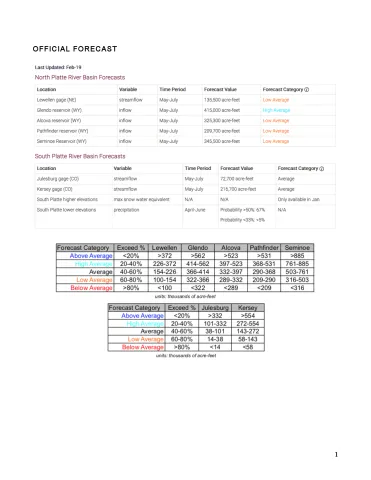
The North Platte and South Platte basin snowpack is currently tracking very close to seasonal normal, which at this point in the season begins to reduce the chances of a very low spring runoff. However, a warm and dry March can quickly reverse this and thus, it is too early to rule out low runoff at this time.
The latest North Platte forecast showed higher projected flows in the lower elevations, with generally lower flow projected for the higher elevations. Notably, the Lewellen projected flow increased substantially again, with the latest value being 136K acre-feet (solidly in the Low Average category). Interestingly, the Glendo forecast of High Average appears like an outlier. However, we speculate that the reason for this is the relatively high current reservoir storage, which can prop up future flow at Glendo since it is the last large reservoir in the North Platte system.