Description
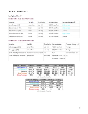
The weak El Nino event in the eastern Tropical Pacific continues. Its affect on the atmosphere continues to be weak to negligible, although the recent few weeks have experienced several storms over the southwest US in a manner reminiscent of an El Nino. Figure 1 shows the 500-mb (~18,000 feet) geopotenital height anomaly over the past 30 days. Note the strong negative (low-pressure) anomaly over the Pacific Northwest, a stark departure from earlier this winter when no such anomaly was seen over western North America and the eastern North Pacific Ocean. Whether this can be attributed to El Nino is uncertain, and it is possible that this pattern change is progressive and will not last long. Nonetheless, sub-surface ocean temperatures remain substantially warmer than normal along parts of the Pacific equatorial region, implying a chance for this El Nino event to re-strengthen. However, this outcome becomes increasingly less likely the farther out from winter we head. Regardless, a weak/moderate El Nino has little to no impact on the North Platte basin, but does imply above normal spring precipitation in the South Platte basin as is currently being forecasted.
